Devils Island is one of the twenty-two Apostle Islands of northern Wisconsin, and has also been known as Louisiana Island (Henry R. Schoolcraft's 1820 map), Barney and Lamborn's Island (Asaph Whittlesey's 1871 map), Brownstone Island, and Rabbit Island.
The island is located in western Lake Superior off the Bayfield Peninsula, and has a maximum elevation of 652 ft above sea level. The island rises only 50 ft above Lake Superior's official elevation of 602 ft. It is 318 acres in area.
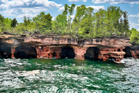
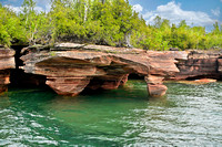
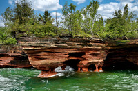
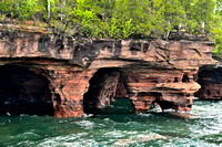
When surf on the lake is heavy, the waves thunder and boom in the island's extensive sea caves. The rumbling can be heard even well away from the shoreline. Local residents claim that the Ojibwe (Chippewa) interpreted this noise as the sound of evil spirits.
The island is perhaps most visited for the dramatic rock formations and sea caves that wrap around its northern shore. It is popular with kayakers who enjoy meandering in and out of the caves on calm days.